 |
| Fig. 2: Study area |
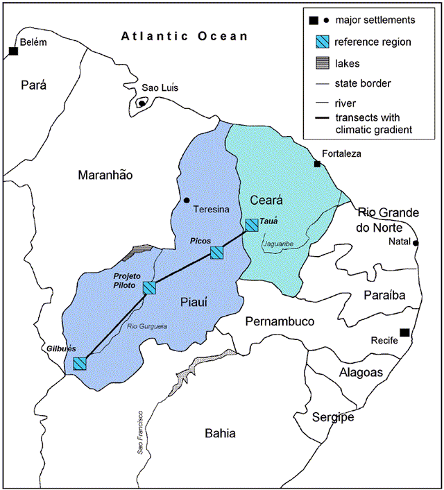
they comprise a west/east gradient regarding precipitation, which should lead to sharply decreasing seepage from west to east
Piauí is situated mainly on a sedimentary basin (porous aquifer), whereas 70% of Ceará are characterized by cristalline rock (fractured rock aquifers)
large ground water resources occur and are already exploited in both states, but sustainability of their use is by far not guaranteed
in the south of Piauí large areas have become desertified
the socio-cultural structures encountered nowadays in Piauí and Ceará are less qualified to solve future problems.
|
|
| Fig. 2: Study area |
.............
| Piauí | Ceará | |
|---|---|---|
| Area | 250.934 km2 | 148.016 km2 |
| Inhabitants | 2.616.900 (10/km2) | 6.626.235 (45/km2) |
| Capital | Teresina | Fortaleza |
| Industry | weakly developed | moderately developed |
| Agriculture | maize, beans, rice, cashew, cowpea, sugar cane, cotton | |
| Climate | - changing trade-wind belt climate
- little rain during winter p.a. 1500 mm (north) 500 mm (southeast) - Tmean ~ 26oC |
|
According to the working methods and contents of the different disciplines, work within the project is carried out on different scales. This depends very much on the testing of different scaling methods, in order to be able to guarantee the transferability of individual results to other scales. These scales reach from macroscale (federal state) over mesoscale (region) to microscale (municipio). The different scales are combined with each other by upscaling and downscaling. This means that each discipline has its own preferred scale, but however, that the other scales have also be considered. This is necessary since there are questions on the macroscale that can only be answered by including the microscale and vice versa. In order to guarantee the integration of the results and thus also the success of the whole project, the municipio was determined as the smallest common geographical reference unit.
Along a climate gradient (approx. 600 - 900 mm mean annual
sum of precipitation), three reference areas (Projeto Piloto/Vale do Gurguéia,
Picos and Tauá) were selected (Figure 2) whose ecological and socio-economic
characteristics lead us to expect a good transferability of the investigation
results to other regions in the northeast of Brazil. This reference area
is compulsory for all disciplines. An extension of the transect into moister
or drier areas is also possible.
More information 3 - Organisational structure